|
Seenyal
|
||
|
L'ai n'aseei
|
Soa-hal
|
Seinjadda
|
|
(Koolayal)
|
(Phulgayn)
|
(Tsippin)
|
|
Seenyal Data
Explanations
Smaller settlements or communites are visible as coloured dots. Karinnin [cloysters] are light blue, other places are drawn in purple. |
Seenyal Lenntay and Communities Detail Map
1000 km Please click here |
||||||||||||||||||
|
Further Information
On the virtual Jiimay-ke--Namdighoy-Tia journey you can visit the "Mounhao Area" [Simh-Mounhao] |
Seenyal on the Ayganyan Map
(Please click to open the Ayganyan map) 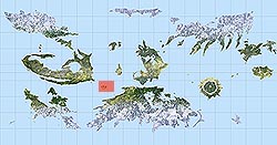 |
||||||||||||||||||
|
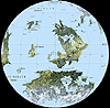
Detailed Seenyal Madogi Map
(Please click to open the Ayganyan map) 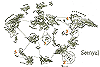 |
|||||||||||||||||||

Back to the Ayganyan Atlas